SIGyHD
Sistemas de Información Geográfica y Humanidades Digitales Unit

SIGyHD is a scientific-technical laboratory, belonging to the Centre for Humanities and Social Sciences (CCHS) of the Spanish National Research Council (CSIC). We work on Geographic Information Technologies (GIS, web mapping, remote sensing, digital cartography, etc.), and digital geohumanities (text labeling, ontologies, semantic web, ect.), applied to Social Sciences and Digital Humanities research, basing our work on transversality, innovation and interdisciplanirity.

SIGyHD is made up of a multidisciplinary technical group that manages data and resources, bringing its specialized training and experience to the development of R&D projects that involve the generation and processing of georeferenced information. Thus, it is possible to analyze the different aspects that interact in the territory, becoming a basic and effective cornerstone for research projects that have a spatial and temporal component.

SIGyHD goals:
To support research from innovation and interdisciplanirity. Our area of work is implemented in Spatial Humanities, with the application of Geographic Information Technologies (GIT) and Digital Cartography to scientific projects on Humanities and Social Sciences.
To provide scientific-technical services, from an interdisciplinary, multi-criteria and competitive approach. Furthermore, based on innovation, transversality and knowledge exchange.
To provide interoperable solutions to scientific projects development in the field of Geoinformation, web mapping or Spatial Humanities. Its applicability covers from Information Sciences or cultural geography to the most recent technologies related to databases, queries and spatial analysis, visualization, web mapping, location based services (LBS), Spatial Data Infrastructure (SDI) or Semantic Web.
The SIGyHD unit through the Exea data infrastructure and services , contributes to Open Science. It promotes free access to data and research projects results, so they comply with FAIR principles and are accessible, intelligible, discoverable, reusable and interoperable, through the adoption of international standards and norms such as those of the Open Geospatial Consortium (OGC) and ISO TC/211. It also colaborates in open science platforms and projects such as the European Open Science Cloud European Open Science Cloud (EOSC) or The Open Source Geospatial Foundation (OsGeo)
GIS Desktop application:
- QGIS is a free and open source Geographic Information System to create, edit, visualise, analyse and publish geospatial information on Windows, macOS, Linux, BSD and mobile devices

WebMapping application:
- OpenLayers facilitates the programming of a dynamic map on any web page and it has been developed to promote the use of geographic information of all kinds. It is open source, completely free, released under the 2-clause BSD license (also known as FreeBSD).

Catalog application:
- GeoNetwork provides powerful metadata editing and search functions, as well as an interactive web map viewer. It is currently used in numerous Spatial Data Infrastructure initiatives around the world.

Database:
- PostgreSQL is an open source, reliable, object-relational database system with feature and performance robustness.

- PostGIS extends the capabilities of the PostgreSQL relational database by adding support for storing, indexing and querying geographic data.

- eXist-db is a native open source XML database of NoSQL documents and an application platform built entirely around XML technologies.

Scientific-technical services provided by SIGyHD
These services involve, most of the time, the implementation of customized solutions for each case and each project, and the support and accompaniment of the unit throughout the life cycle of the generation of scientific data and research projects of the CCHS Institutes.
SIGyHD offers services, mainly related to:
- Conceptual modeling of project information/data.
- Structuring in georeferenced (and non-georeferenced) databases.
- Generation of Geographic Information Systems (GIS), according to interoperability standards and FAIR principles.
- Programming of distributed data loading interfaces.
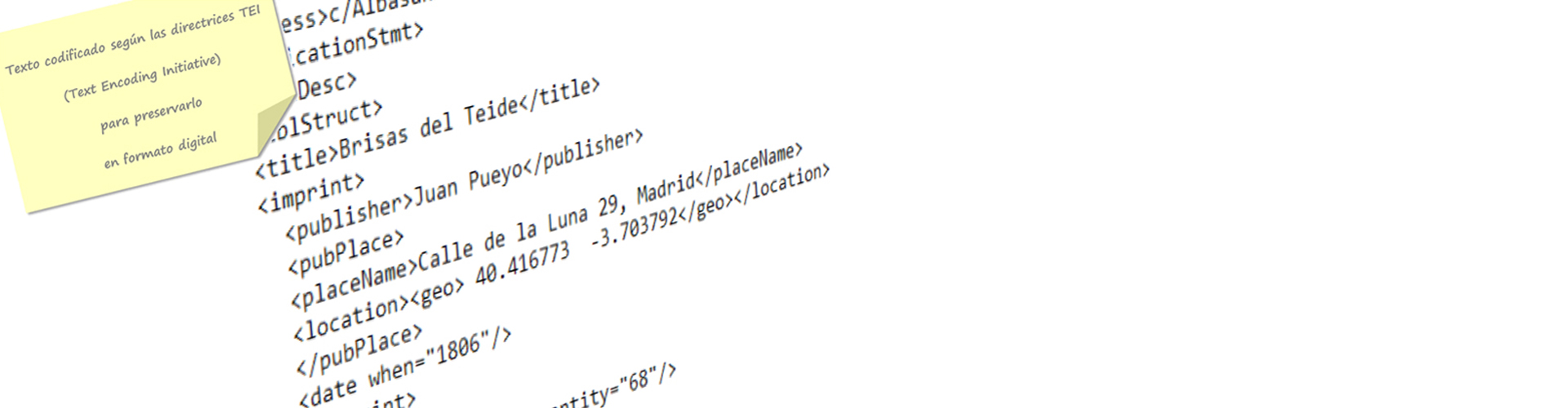
- Application of HD technologies for textual corpora.
- Spatial-temporal data análisis.
- Development of webmapping applications for interactive visualization and downloading of project data, customized to the open science framework.
The list of scientific-technical services of SIGyHD and their description are available through its Service Charter or the CSIC's Catalogue of scientific-technical services.

Publications
- Books & Chapters
- Articles
- Conferences
- Reports & Outreach Materials
- DIGITAL.CSIC an institutional repository of the Humanities and Social Sciences.