Access to data from about 1900 archaeological sites and Rock Art of the Iberian Peninsula
IDEArq. Archaeological Research Spatial Data Infrastructure
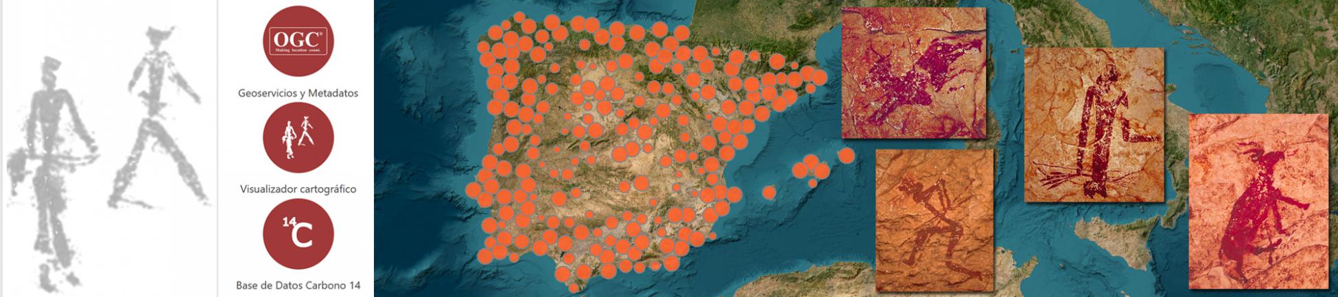
A long process of structuring datasets provided by different research groups allowed the implementation of this ambitious project that offers visualization on a webmap, filtering and downloading of information on Radiocarbon dating, Levantine Rock Art and Isotope Analysis of more than 1900 sites.
"IDEArq offers all researchers interested in the Recent Prehistory of the Iberian Peninsula a source of primary georeferenced research data."
Juan Manuel Vicent García
Instituto de Historia. CSIC
Carbon 14 is a data base of over 8000 dates for archaeological objects and sites from Andorra, Portugal and Spain. It includes bibliographic, analytic and contextual information. The dates range from the Palaeolithic to the end of the Roman Empire with emphasis on the later prehistoric and protohistoric periods.The archive is derived from a date list assembled by Professor Antonio Gilman (California State University, Northridge) from the archaeological bibliography for the Iberian Peninsula; those collected by Professor Rafael Micó (Universitat Autònoma de Barcelona) and those courtesy of Antonio Rubinos (Instituto de Química Física Rocasolano - CSIC).
Corpus de Pintura Rupestre Levantina (CPRL) is a set of photographs made between 1969 and 1974 at the principal Levantine rock art sites known at the time. It contains over 3000 images from 94 localities and incorporates abundant ancillary documentation.It is the product of a project carried out under the direction of Prof. Marín Almagro Basch in the then Institute of Spanish Prehistory of the CSIC. The photography was done by Fernando Gil Carlés.
δimP, the dataset for Iberian diet and mobility, is a geo-referenced database of isotopic values of strontium, oxygen, carbon and nitrogen obtained from human and animal remains recovered from archaeological contexts of the Iberian Peninsula.
IDEArq offers several self-developed features that allow the display, consult and download of research data
Access is through an online map-based interface, although accurate position of sites is not shown and visual scale is limited to 1:200.000 in order to protect their actual location.
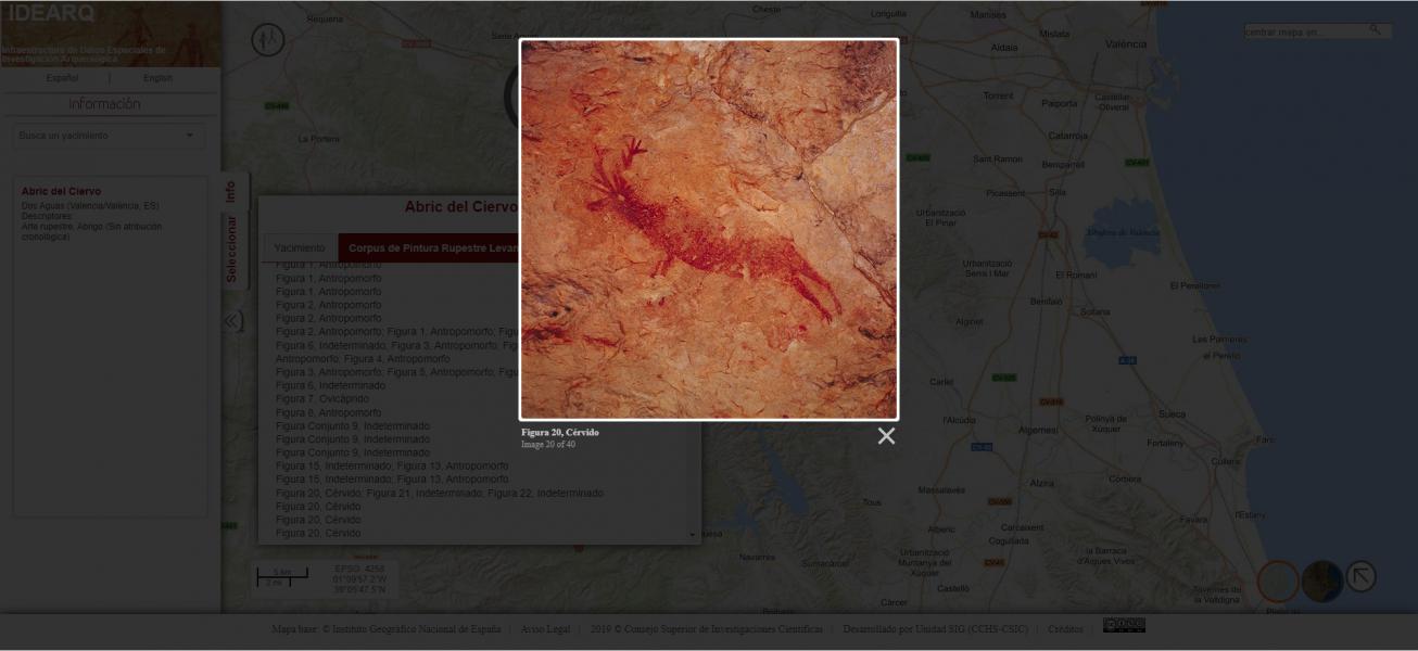
Access to the CPRL from the web map.
Engaging products about Carbon 14 have been developed for researchers interested in Peninsular Prehistory:
Web interface for database queries.
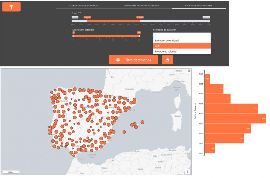
Carbon 14 Interface
Analysis of the impact of dated materials and dating methods on the result accuracy .

This interactive graph allows the visualization of dating as points, comparing the influence of different qualitative dimensions (type of dated material and dating method) to the resulting standard deviation, [symbolized] represented by the size of each point.
The georeferencing of sites opens the door to the diffusion of research data implemented on the principles of interoperability of the INSPIRE directive (Infrastructure for Spatial Information in Europe).
IDEArq is a project that strives to disseminate archaeological research of the Centro de Ciencias Humanas y Sociales (CCHS) of the CSIC. It goes a step beyond direct download of data from the website by generating interoperable map services according to OGC (Open Geospatial Consortium) specifications and metadata conforme a la normativa ISO para datos georreferenciados (ISO serie 19100). according to ISO standards for georeferenced data (ISO 19100 series). This means that anyone can discover IDEArq from the IDEE (Spatial Data Infrastructure of Spain)catalog, and incorporate it into their desktop Geographic Information System or webmapping project.
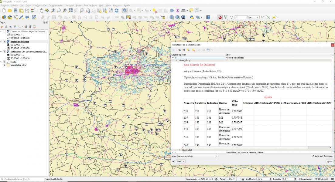
IdeArq services loaded in a GIS
All map services maintain the limitation of visual scale to 1:200.000 and the rounding of sites coordinates to 1 km.
The design of an open data model is the centerpiece for the systematization of all IDEArq information.
The first task when approaching this project was the development of a data model that accurately describes all the existing information, its attributes and relationships. The joint work of archaeologists and technologists led to a precise definition of classes and relationships expressed in UML (Unified Modelling Language) and subsequently implemented in a PostgreSQL-PostGIS relational database.
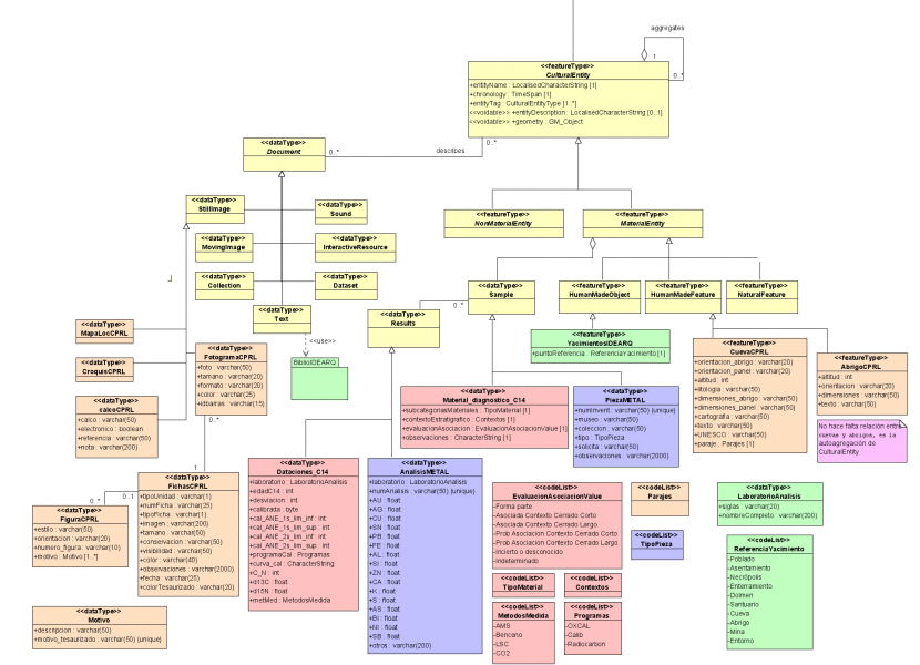
Part of the UML Data Model
Web platform presentation, its goals, datasets, specific technical features, functionality and potential of the system, as well as future perspectives.

Source: Museo Arqueológico Nacional de España (MAN)
Coordinator Juan Manuel Vicent García - IH (CSIC)
His work has focused on the archaeological societies of late prehistory (Neolithic, Chalcolithic and Bronze Age) in Iberia and the Western Mediterranean, as well as their comparative correlates in other parts of the world (Eurasian Steppes, America and the Pacific).
read more...
IDEArq is the result of the joint work of researchers from the Instituto de Historia and the Unidad de Sistemas de Información Geográfica y Humanidades Digitales del Centro de Ciencias Humanas y Sociales (CSIC).